Lidar Product
ID
40152381
-
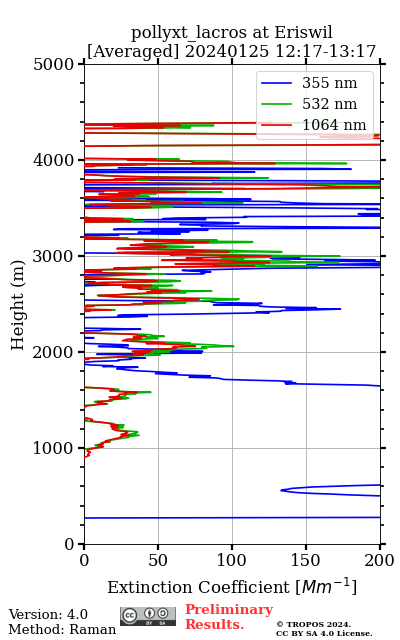
Imagerecent_plots_24h/pollyxt_lacros/2024/01/25/2024_01_25_Thu_LACROS_00_00_01_1217_1317_OC_Ext_Raman.png
-
Location | Lidar
-
Product category
-
Product typeAveraged extinction profile from Raman method overlap_corrected
-
Active
-
InfoMeteorological data from GDAS1 at eriswil on 20240125 12 UTC. Reference height is [ 2185.4 - 3679.7m] (355nm), [ 2103.2 - 3590.1m] (532nm) and [ 4314.8 - 5129.2m] (1064nm). Smoothing window is 457.5m, 457.5m, 457.5m. If SNR for Raman signal at reference height is low, the Raman method will not be applied.
-
Related lidar data
-
Starttime
2024-01-25 12:17:30 -
Stoptime
2024-01-25 13:17:00 -
Stored/Updated in database
2024-04-22 06:43:35