Lidar Product
ID
41255772
-
Imagerecent_plots_24h/pollyxt_tropos/2018/06/09/2018_06_09_Sat_TROPOS_00_00_01_1910_2009_OC_Ext_Raman.png
-
Location | Lidar
-
Product category
-
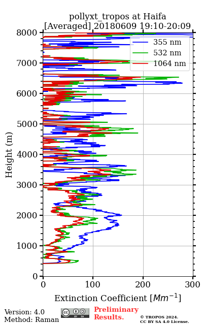
Product typeAveraged extinction profile from Raman method overlap_corrected
-
Activedone
-
InfoMeteorological data from GDAS1 at haifa on 20180609 21 UTC. Reference height is [ 6444.1 - 7938.4m] (355nm), [ 6959.7 - 8058.0m] (532nm) and [ 5891.3 - 6892.4m] (1064nm). Smoothing window is 457.5m, 457.5m, 457.5m. If SNR for Raman signal at reference height is low, the Raman method will not be applied.
-
Related lidar data
-
Starttime
2018-06-09 19:10:00 -
Stoptime
2018-06-09 20:09:30 -
Stored/Updated in database
2024-05-05 16:42:17